|
|
|
|
|
The Changing Face of the High Street
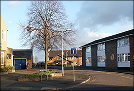
The Latimer Close/Band Club Area
|
|
|
|
|
|
|
|
|
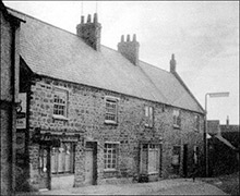
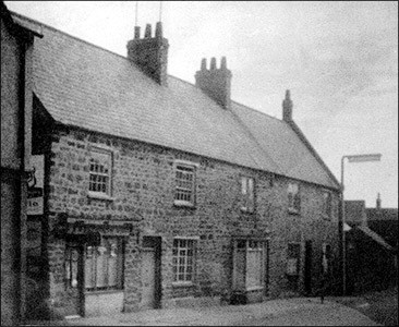
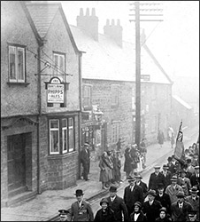
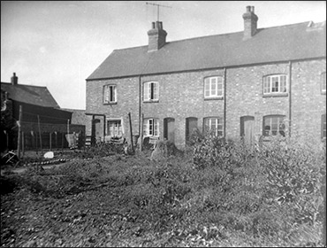
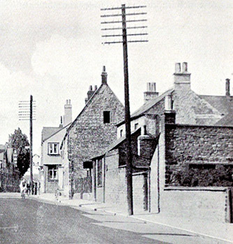
Left - the High Street frontage in the 1950s
|
|
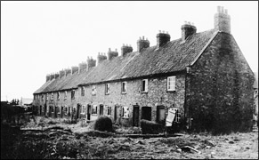
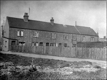
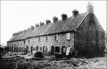
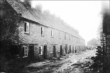
Right - Long Row cottages, shortly before demolition
|
|
|
|
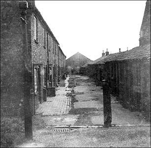
| The whole area occupied by Latimer Close and Burton House was until the 1960s home to dozens of people living in terraces and yards made up of mainly brick cottages. These were part of the development of the Burton in the mid-late 19th century, when it was still a considered a village. The area lay between to Duke's Arms and The Band Club, and extended eastwards towards the old brickyard and open fields. It comprised School Lane, Long Row, Ambler's Yard (also known as Band Club Yard) and the whole area tended to be referred to by the name of another small set of houses: Croxen's Yard, named after John Croxen, landlord of the Duke's Arms, who was also involved in the brick and tilemaking which went on in the latter part of the 19th century. |
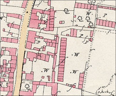
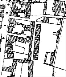
The 1886 Ordnance Survey map (right) shows Duke Street at the top left, with Pigotts Lane joining the High Street further down. Two lanes are shown going eastwards: the top one, next to the Duke's Arms, was known for a while as School Lane when the Infants School was built on the area shown here as an orchard or paddock. By the middle of the last century it was called Croxen's Yard, a name originally given to the row of six cottages on the north side of the lane, running in a north-south direction immediately behind the Duke's Arms. Running east-west along the north side of the orchard are the Salt Box Cottages, deliberately destroyed by their tenants in 1910. Further down the lane, also running east-west are the Brickyard Cottages.
The main feature of the complex, however, is the huge terrace of houses running north-south. This was Long Row, (sometimes called Croxen's Long Row). The west side of the a row was the frontage, with an equally long row of outhouses, wash-houses and outside toilets on the opposite side of the yard.
A final north-south terrace of four cottages stood further to the east, alongside the brickyard.
|
 |
|
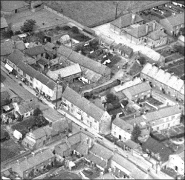
Croxen's Yard Area in 1923
This aerial view shows the Infants School (top right) and next to it, the first homes in Brickyard Cottages. Croxen's Yard proper is in the upper centre, and below it Ambler's Yard.
The northern end of Long Row is on the mid-right.
The old Band Club is the stone building set back from the High Street. Below it to the right is the corrugated iron hall referred to below.
The small shop on the pavement between the Band Club buildings is Tailby's shoe repair business.
The stone cottages which fronted the High Street between the Duke's Arms and the Band Club are shown to good effect in this shot. The two shops 9see below) can easily be picked out.
|
|
|
By the time the 1928 Ordnance Survey map appeared (see right), very little had changed, apart from the building of the Infants School (top right on the map).
The Band Club had been extended by the addition of a large hall of corrugated iron on its south side (marked 'Club' on the map); some extra sheds and outbuildings had appeared at the ends of some of the gardens in various properties, but essentially, the scene was the same as it had been fifty years previously.
On the north side of the Band Club, opposite Pigotts Lane, was a small lane leading to a small complex of cottages. This was Ambler's Yard, probably named after members of the Ambler family who built and owned several properties in the immediate vicinity. Because of its closeness to the Band Club, it was also known as Band Club Yard.
|
 |
 |
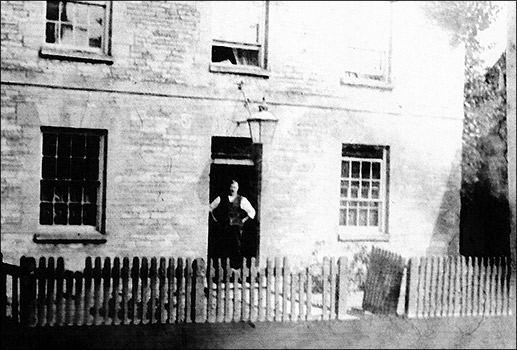
The old Band Club
Left - the stone building which housed the original club. Right - the degree to which it was set back from the road can be seen
in this view from about 1950. The sloping roof of the corrugated iron building can just be seen on the right of the picture
|
|
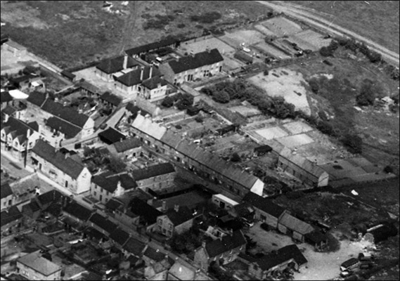
Croxen's Yard Area in 1950
This aerial view shows the whole of the area. The major changes are still to come, with no demolitions since 1923. This is probably the best photographic reference image for anyone whose ancestors are shown by the Census records as living in this part of the town.
All the features shown on the maps above can be made out, in particular the whole length of Long Row.
Close inspection shows all the sheds and outhouses which had been added since 1886.
The former brickyard to the east was by now waste ground, used for the storage and breaking of old cars.
It is sobering to think that of all the properties shown in this photo as being south of the Duke's Arms, the only ones which are still standing today arethe former Methodist Chapel in the lower centre of the shot, and the terrace of four houses (mid-right) facing the former brickyard.
|
|
 |
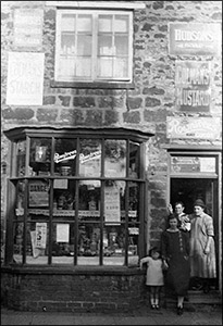
Between the Duke's Arms and the Band Club, the High Street frontage to the whole Croxen's Yard complex comprised a series of four stone cottages. The northernmost one, the one on the corner of School Lane/Croxen's Yard entrance was a shop. in the early part of the last century it belonged to the Hickmans, and the long narrow extension at the back (see map) was used as a tea room. The Papworth family took over from the Hickmans, and carried on the business until final closure. It was a general stores, tobacconists and sweetshop - being close to the schools, the sweetshop was much patronised! Many an old Burtonian will recall the 'clack' of the brass latch as you opened the door, the step down onto the tiled floor, and the array of jars full of sweets which met the eye.
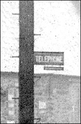
Next door was the original location of Burton's first telephone exchange, in the upstairs front room. Then came another shop - a general stores run by Ada Mason until the 1920s. The final double-fronted property was privately owned, but served for a time as a surgery for a travelling dentist.
|
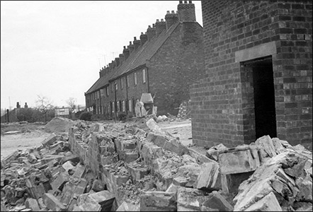
The major changes to this area began in the 1960s. Social change was in the air, and there was a general drive, nationally, to upgrade older housing, usually by a process of demolition and rebuilding. Plans had been drawn up in 1957 for a programme of social and sheltered housing for this part of Burton; it was postponed at first, but later went ahead.
Development programmes at this time generally came under the heading of "Slum Clearance". From a 21st century perspective, the process may sometimes seem like over-zealous destruction of old properties, many of which would nowadays be judged as having real character. However, the attitudes of the 1960s were fixed on new developments rather than older things. The advertising buzzwords heard so often on TV and seen on posters were "new and improved", and in fairness, building maintenance techniques had not yet advanced far enough to deal effectively with many of the structural problems found in older properties. Rising and penetrating damp constituted real problems, and if offered a clean, dry, newly-built house with an indoor bathroom and toilet, who - seriously - would refuse it, especially when tenants of the old cottages were to be offered new flats and homes built on the old site? So the demolitions began.
The High Street was demolished to give access to the whole area. Early in 1960, Brickyard Row was demolished, followed by Croxen's Yard and then Long Row in 1962.
|
The redevelopment, seen in an aerial shot from 1971
|
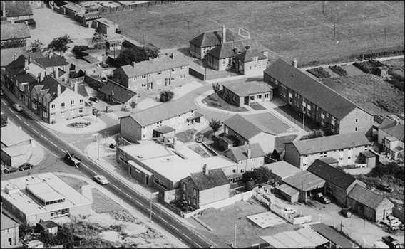 |
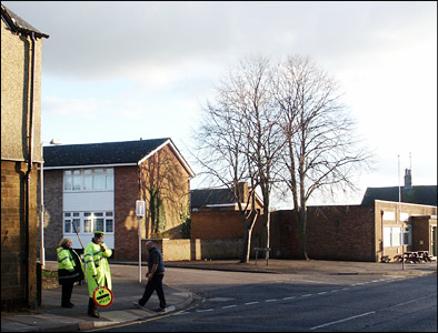
The redeveloped area was named Latimer Close. Burton House - a necessary facility of sheltered housing and social space for elderly people - stands where Long Row once stretched southwards. Further development in the 1980s and 90s has seen the site of the old brickyard disappear, though the Croxen name lives on as Croxen Court.
Click here to view a movie clip of the High Street frontage of Croxen's Yard prior to the demolition and redevelopment
Click here to view a movie clip of Latimer Close at the very beginning of the redevelopment
To view the clips correctly, you may need to download the Quicktime Player if you don't have it installed. Users with a dial-up connection are asked to be patient during the loading time.
Movie clip courtesy of Carol Desborough
|
|
|
|
|
|