The Changing Face of the High Street
Kettering Road Area

Rock Terrace c.1905

The date stone

Church Street Autos 1966
Anyone looking at the modern townscape at the north end of the High Street might suppose that Kettering Road begins at its junction with Station Road. This however is an error. According to the best available information in the Society’s archives, Kettering Road has always begun a hundred and fifty metres or so earlier – at the junction with Bakehouse Lane, and at certain times was even deemed to have included Rock Terrace.
The first set of buildings on the north side of Kettering Road were shops, then followed a range of buildings belonging to Redlands Farm, then came the Waggon & Horses public house. The south side started with a stone terrace before opening right out to undeveloped land. A few cottages fringed the road before the corner of Station Road. This part of the town was therefore a mirror of Burton’s early years as it developed from a village to a town: a farm, an inn, a few shops, and mostly small stone cottages housing families whose occupations came from a range of manual skills, such as labourers, shepherds, tailors, seamstresses and shoe repairers.
Below is Kettering Road from Bakehouse Lane Station Road on the Ordnance Survey map of 1886. The size of Redland Farm on the north side can be appreciated here. The buildings attached to the Waggon & Horses (reversed L-shape and marked P.H. here) and which fronted Kettering Road, were two-storey buildings which served as cottages tied to the farm. They were demolished in the early-mid 1960s. The space is currently a car sales lot. On the south side, a row of cottages – some also being shops – gave way to a wide open space, before further cottages led to the shop on the corner of Station Road.

By the early years of the 20th century, the shoe and clothing trades were firmly established, and the balance of work had shifted from agricultural to light industrial. Two large factories occupied spaces behind Kettering Road.
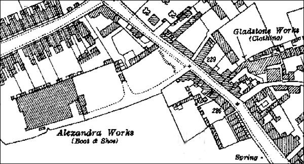
Below is the layout shown on the Ordnance Survey map of 1928. Little has changed as far as the street frontage is concerned, but Gladstone Works (the home of Hart & Levy) and Alexandra Works, built by Buckby Brothers in about 1903, have made this area of town a part of its industrial activity.
Below is a view from the early part of the last century. The shop on the corner of Bakehouse Lane has had a number of uses. Click here to read its history. The next shop was for many years Gilby’s Off-Licence. Some of the farm buildings of Redlands Farm can also be seen.

Below, a similar general view in 2007. The demolition of Rock Terrace and the other buildings on the south side of Kettering Road now gives a much clearer view of these old buildings, which are now in the extended Conservation Area. The new arched entrance in the old farm building gives access to some residential properties which were built in the 1990s on part of the former farm site. In 2010, the frontage of the former off-licence was remodelled to make a residential building, so all traces of the former shops have now gone, though close inspection of the photo will show where some of the former doors and windows were located.

Some shops on the South Side of Kettering Road.

the 1956 Gala Day parade passes Watts’ shop at 1 Kettering Road.
This shop has had a very varied history. Click here to read about it.

Wallis’ shop at number 11. Joseph Wallis was a greengrocer and fish merchant

The scene in the 1930s. The entrance just beyond the telegraph pole was known as Pownall’s Opening.
Robert (“Bobby”) Pownall ran a bakery business on this site.

In March 1916 a heavy blizzard hit central Northamptonshire. As can be seen here, telegraph
poles snapped under the weight of snow on the cross-bars and wires. In this photo, the whole of the
stone terrace which marked the end of the first section of kettering Road can be clearly seen. It was this
terrace which was the first to be demolished when the road widening came in the early 1960s.
The Constitutional Hall
For a short period of time, probably no much more than fifteen years, a wooden-framed structure clad in corrugated iron panels occupied part of the large empty space between the terrace and the other cottages along the south side of Kettering Road. It is not on the OS maps of 1886 and 1928, above.
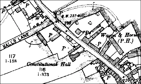
This building was the Constitutional Hall (see map above). Amongst other things, it housed the meetings of the Latimer Habitation of the Primrose League, and one of its uses from 1912 was as a venue for meetings of the Conservative Club before the building was demolished in about 1915. As can be seen from the map, it had a T-shape plan and was approached by a path running from a curved gateway in Kettering Road. After its demolition, half of the building was acquired by Mr Alfred Barratt who had it moved to the back garden of his house (Collingwood in William Street), where it served as a store for his business (he was a harness dealer).

Part of the former Constitutional Hall in the back garden in William Street in 1971. This is the only known view of the building.

This is confidently thought to be the interior of the Constitutional Hall. The original photograph had the hand-written caption: “Preparation for Banquet at King Edward VII’s Coronation”, which would put the year at 1902.
Kettering Road - North Side
The main feature of the north side of Kettering Road was the Waggon & Horses pub. It was adjoined on the east side by two cottages belonging to Redland farm. These were demolished in the early-mid 1960s and the site became a second-hand car lot, which it remains today. The pub continued to trade as a public house until it closed in 2010. It is now a residential property.

Beyond the Waggon & Horses was a stone-built house, which in 1901 belonged to the Paynes. Affer the death of her parents, Ethel Payne had a bungalow built in the grounds on the west side – sometime in the middle years of the century – and moved in there. Further on, almost opposite the bottom of Station Road, a large detached house was built in the 1920s.
Kettering Road - South Side
Shown below is the south side of Kettering Road as shown on the Ordnance Survey map of 1938. The area between the road and the shoe factory was the one known as Coleman’s Green.
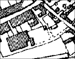
With the shoe factory built and the Constitutional Hall gone, a large open space lay between the factory and the road. this became known as “Coleman’s Green”, named after a Mr Sidney Coleman son of the licensee of the Waggon & Horses. He had a workshop on the open space. The open space was used as a winter site for travelling caravans in the 1930s-50s, then it became a filling station.
Next past the green was Joe Sharpe’s cottage, then two other buildings built higher than street level. They were approached from a steep sloping access at the rear. Fianlly on the corner of Station Road was a bakery and retail shop.
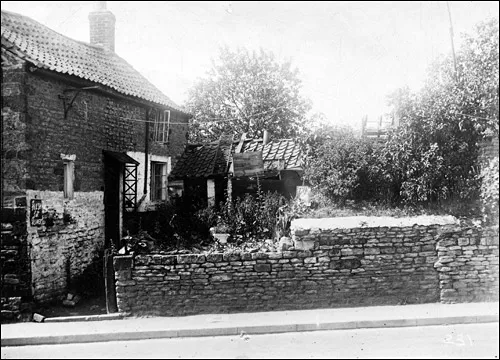
Joe Sharpe’s Cottage at 35 Kettering Road
The sign on the nearside corner of the cottage reads
“Fresh Cut Flowers” – a useful source of additional income for this
town postman, and one which took advantage of the number
of frequent passers-by.
The view down Kettering Road in about 1905
The end of Joe Sharpe’s cottage can be seen on the right,
along with the two high-level cottages mentioned above
The Paynes’ house is on the left
Station Road Corner

Norton’s Bakery in the 1920s

The same scene in 2007

Kettering Road / Station Road corner 2007
This view shows just how much of a drastic alteration to
the building took place. Though it is now a private residence,
the dark sections of the white rendered wall reveal the original
shop door and the display windows.
1960 - The main demolitions begin

The 1950s saw an increase in the volume of road traffic down the A6, and demands to “do something” about the bottleneck opposite
The character of this part of town had changed forever, and looking at the old photos above really is like looking through a window onto a very bygone age.