Click here for the Glossary page
Click here for the main index of the Burton Latimer Heritage Society site
Click here to return to the previous page
Presented by Margaret Craddock
Allotments

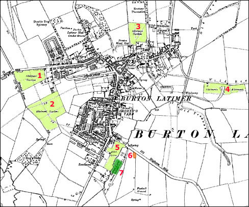
Ordnance Survey Map of the town in 1938. Light green areas show allotments then in use.  Small orange patch shows the small plot in use in the late 1940s.  Dark green area indicates the current location of the modern public allotments
The Ordnance Survey Map of Burton Latimer in 1938

The light green areas show the allotments then in use. The small
orange patch shows the small plot in use in the late 1940s. The dark
green area indicates the current location of the modern public allotments

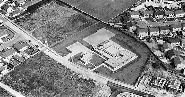
When the Parish Council was formed in Burton Latimer in 1895, one of their first commitments was to establish allotments for the town. The area designated was to the south of Station Road in the area now known as Glebe Road (number 1 on the map above). Later, a large area (number 1 on the map above) was available for many years from the south of Regent Road, extending to the top of Finedon Street, until the development of housing estates extending from Nene Road, Park Road and Queensway, into Churchill Way. The photograph below shows the area in 1971, following the construction of Meadowside School, with rough ground being the location of the remnants of the allotments.

Meadowside School and Park Road under construction, showing some of the new houses recently built on allotment sites.  Two areas of rough ground can be seen where the allotments were previously used with some of the plot outlines still just visible.
Meadowside School and Park Road under construction, showing some of the new houses recently built on allotment sites, together with two areas of rough ground where the allotments were previously used. Some of the plot outlines are still just visible.

The National Society of Allotment and Leisure Gardeners were established in the town in 1912. The current site (number 7 on the map above) has a 10-year self-managing lease at a peppercorn yearly rent of £1 from Kettering Borough Council. It is on a 4.5 acre site at the end of Jacques Close off Higham Road. In 2010 the plots are worked by 65 people and there has been a waiting list of 15 people for the past 8 years. Efforts are currently being made to extend the allotments into the field at the far end of the site in order to accommodate the demand for plots. The allotments are well maintained and water is available from a spring at the top of the site together with access to the brook at the bottom of the plots. The secretary/treasurer of the Burton Latimer Association is Mr Martin Turner.

Article from the Northamptonshire Evening Telegraph, 23 November 2010, by Clive Whittingham

The trend for growing your own vegetables is putting pressure on allotment associations.As more people turn their back on mass produced vegetables, associations are finding it tough to accommodate all the budding gardeners

The problem is particularly acute in Burton Latimer where people face a two-year wait for a plot and the association is asking the town council to find it some more land.

Burton Latimer Allotments Association secretary Martin Turner said: “The main problem is securing land on a longer term lease.  It would be a total waste of time to take a piece of land for only a year or two.

“There is a clamour for plots all over the country.  People have decided they want to get exercise and grow their own vegetables – it’s going back to how it used to be.

“When I started as secretary 25 years ago we had 22 plot holders and now we have 65 gardeners with 13 on the waiting list.

“I’m getting requests for plots all the time – people are on the waiting list for two years before they get a plot.

Mia Grainger, a working mum who holds a plot at the allotments off Jacques Road with three friends, said: “We have had the plot for over a year, and we had to wait for a year to get it.

“We live next door and watching people coming and going with wheelbarrows of fruit and vegetables encouraged us.

“It’s tough going sometimes but you can’t beat the flavour of the stuff you pull out of the ground.”
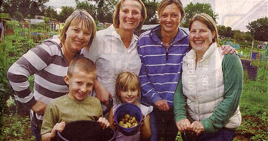
Current allotment holders on the site off Jaques Road.  Lisa Roberts, Mia Grainger, Caroline Finn and Helen Sanders with Jack Grainger and Ellie Grainger
DIGGING IN - Lisa Roberts, Mia Grainger, Caroline Finn and Helen Sanders
with Jack Grainger, seven, and Ellie Grainger, five

Mayor of Burton Latimer Cllr Maureen Jerram said: “The town council is working with a two-pronged attack on this.

“Cllr Ruth Groome is asking what can be done through Kettering Borough Council.  We are also trying to make an agreement with lease holders of neighbouring land.

“I desperately want to help.  The best scenario is to look at land adjacent to the site but we would be willing to look elsewhere.

Kettering Allotment Association chairman Brian Mitcheson said: “We have a waiting list that just seems to keep growing.

“On our smaller spaces people have to wait longer, but at the bigger sites people are  waiting three months.

“We are giving people half plots, just to get them started.”

Privately owned allotments exist to the east of properties in Finedon Road (part of area 5 above) together with a small area owned by the Police Authority. These are still in use today, though the houses and bungalows of Ensleigh Close have been built over the area at the Higham Road end.

In the past, several private plots fronted Finedon Road opposite properties 32-36 (part of area 5 above). In the late 1940's plots were worked on the south side of Higham Road and children from the local Council School were given gardening instruction there (number 6 on the map). Other areas where allotments were in operation were close to the former Preston Hall and Spinney Road (number 3 on the map), and just off Wold Road (number 4 on the map).

The following extract is taken from The Official Guide book of Burton Latimer published c1950:

"Allotments: Cranford Road Housing Estate (Council Allotments) (2 acres); Allotment Association (17 acres); Station Road (Jacques) (12 acres); Finedon Road (3 acres); Old Orchard (5 acres). - Area: 2,756 acres."

Click here to return to the Main Index
Click here to return to the Agriculture Index