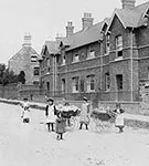
A view from c.1910The house in 2005The same view in roughFor the recreation of the High Street as it once was, every building which stood in 1918 must be reconstructed. Archive photos are being used to show earlier forms of buildings which still stand, or to show...
Report Following Visit To Cottage Homes By Uxbridge Union In 1899
Extracts from Report in the Uxbridge & West Drayton Gazette 27th May 1899Cottage Homes 1910In 1899 the Uxbridge Board of Guardians were sending boys and girls to Ipswich because they had no suitable accommodation in Uxbridge and were investigating an alternative...
Children at the Cottage Homes and Workhouse 1896 – c.1930
Researched and compiled by John Peck 2006The listing shows as far as possible all the known children who were the responsibilty of the Kettering Board of Guardians from 1896 to 1930. The great majority will have spent some time in residence at the Cottage Homes in...
High Street (South), Finedon Road and ‘New Town’
John Meads 2016Finedon Road Mission RoomsMoving south down the High Street past the remaining stone cottages on the western side of the street the character of the streets changes to Victorian red brick. The most important house south of the previously described areas...
Rock Terrace
Rock terrace c.1905The date stoneChurch Street Autos in 1966Rock Terrace was a row of six redbrick terraced houses which ran northwest-wards from what was later to become the bottom of Pioneer Avenue up to a point opposite the entrance to Bakehouse Lane. A date stone...
The Pigott’s Lane Area
The area on the western side of the High Street between Duke Street and Pigott's Lane has completely changed over the last fifty years, to the extent that no part of the original frontage now remains. The 1886 Ordnance Survey map (below) shows a High Street frontage...
Nichol’s Yard/Cooper’s Yard
Nichol's Yard, as seen from the west in an aerial view from 1950Hilly Farm is on the right-hand side of the photoThe east side of the High Street, northwards from the former farmhouse of Hilly Farm, is currently lined by a stretch of plain wall. Until the mid-1960s,...
Mason’s Garage
The site in 1947New pumps in the 1960sThe site in 2009For many years during the last century, a garage/filling station occupied the site where Budgens now stands at the south-east end of the High Street. Most Burton people referred to it as “Mason’s Garage” or “the...
The Latimer Close/Band Club Area
The High Street 1950sThe same view todayLong Row cottagesThe whole area occupied by Latimer Close and Burton House was until the 1960s home to dozens of people living in terraces and yards made up of mainly brick cottages. These were part of the development of the...
Kettering Road Area
Rock Terrace c.1905The date stoneChurch Street Autos 1966Anyone looking at the modern townscape at the north end of the High Street might suppose that Kettering Road begins at its junction with Station Road. This however is an error. According to the best available...
The High Causeway & Wallis’ Yard
The High Street in the 1950sThe High CausewayWallis' YardAs the High Street rises steadily from the junction with Newman Street towards the corner of Pigotts Lane, it currently passes the Library and the former Health Centre. The pathway on the west side of the street...
The Co-op
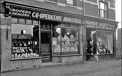
The three photos above show the changes to this site over the hundred years between 1905 and 2005For most people living in Burton in the last century, "The Co-op" was a series of shops (later one large shop with a number of sections) occupying the area between...
The Changing Face of the High Street – The Co-op
The three photos below show the changes to this site over the hundred years between 1905 and 2005This needs to be changed!This needs to be changedThis needs to be changed!For most people living in Burton in the last century, "The Co-op" was a series of shops (later...
The Changing Face of the High Street – Introduction
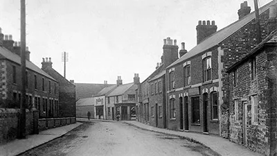
"Gone for a Burton" - some of the houses and cottage which once lined the High Street.Only the buildings past the end of Bakehouse lane remain.The Library and the Harold Mason Centre occupy the site of the cottages on the left; everything between the two telegraph...
The Changing Face of the High Street – The Central Area
Newspaper article transcribed by Sally CraneThe wall and farmhouse of Denton's Farm, fronting the High Street in the 1950sthe same view in 2006, showing the entrance to Churchill way and the shopping development.The building beyond the farmhouse in the 1950s shot is...
The Changing Face of the High Street – A View from the 1930s
Interview dated 1993 transcribed by Raylee BurtonThe High Causeway C.1925The following article is based on an interview with Douglas Ashby in 1993. Douglas had lived at Buton Latimer since his birth in 1928At the junction of Kettering Rd/High St from earliest memory...
A Child of the ’50s – Life at 46b High Street
Article by Bill Watson, October 201046b High Street, Burton Latimer, in October 2010 - seen from the yard behind the shopsI was born at St.Mary’s Hospital in Kettering on the 12th of April 1956. My parents, Margaret and Wilfred Watson lived in the top floor flat at...
Pownall’s Corner
John Meads 2017Until road improvements in about 1960, Pownall's Corner was one of the most notorious bottlenecks along the whole length of the London to Carlisle trunk road - the A6. Situated where the High Street met Kettering Road it was said that an active man...
Burton Latimer Post Office 1850 to 2014
For a number of years, Burton latimer had no post office of its own, and had to rely on a runner service to and from Kettering. As the town expanded, a number of the local population found this unsatisfacory, as can be seen by pressing the button below in a letter...
Conservation Area
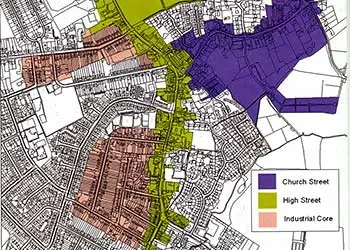
Researched and presented by Margaret CraddockA Conservation Area in the town was established on the 18th March 1981 as a result of a recommendation to Kettering Borough Council by the members of the Burton Latimer Town Council. Mr Douglas Ashby, a member of the town...